Calculating driving distance one pair at a time on Google Maps is tedious when you have dozens or hundreds of locations. Maply lets you upload all your locations at once and get driving distances and travel times for every pair in a single batch — no manual lookups needed.
How to Calculate Driving Distance for Multiple Locations
Need distances between dozens or hundreds of locations? Upload your data from a spreadsheet (CSV or Excel) — each row containing an origin and destination. Maply calculates all pairs simultaneously, saving hours of manual lookups on Google Maps.
Step 1: Create a network map on Maply.
Step 2: Upload your location pairs from a spreadsheet. Addresses are geocoded automatically.
Step 3: Click “Get Driving Distance” from the layer menu. See screenshot below.
Step 4: View results in the data table and export to CSV.

When the processing is finished, you will be directed to the Data Table page to view and download the driving distance and time.
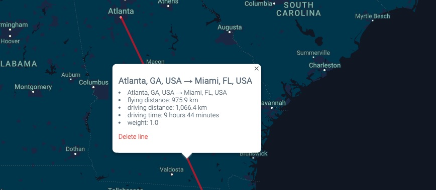
On the map, when clicking on the line connecting an origin and a destination, driving distance and time are also displayed.
What Data Output Do You Get?
For each location pair, Maply returns:
- Driving distance in kilometers and miles
- Driving time in hours and minutes
- Average driving speed
- Straight-line (flying) distance for comparison
All results can be exported to CSV with one click, including origin and destination details.
Below is a screenshot of the data table of an example output you can get. Besides driving distance, time and average speed, Maply also gives you summary of total driving distance and duration. All is available for download into CSV.
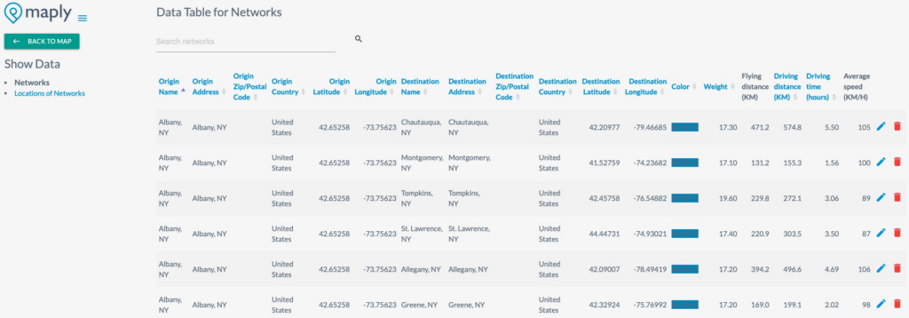
Screenshot of a data table output of a driving distance calculation from Maply
Driving Distance vs Straight-Line Distance
Straight-line distance measures the direct path between two points — as the crow flies. Driving distance follows actual roads, accounting for highways, intersections, detours, and the real road network. For planning deliveries, sales routes, or commutes, driving distance gives you the accurate, real-world figure. Driving distance is typically 20–40% longer than straight-line distance, depending on the road network.
Batch Processing – Up to 5,000 Location Pairs
Unlike single-pair calculators, Maply processes hundreds or thousands of location pairs in one request.
| Plan | Per Request | Daily Limit | Monthly Limit |
|---|---|---|---|
| Free | 100 pairs | 400 pairs | 1,200 pairs |
| Pro | 1,000 pairs | 4,000 pairs | 12,000 pairs |
| Max | 5,000 pairs | 20,000 pairs | 60,000 pairs |
Traffic-Aware Estimates
Set a specific departure time to get travel estimates that factor in typical traffic conditions. Maply uses Google’s real-time and historical traffic data to provide more accurate drive time estimates for rush hours and peak travel periods.
Common Use Cases
- Logistics and delivery planning — Calculate drive times between warehouses and delivery addresses to optimize dispatch schedules
- Sales territory analysis — Measure actual driving distances from sales reps to clients across a region
- Real estate and site selection — Compare commute distances from potential office or store locations
- Healthcare access — Measure patient travel distances to clinics and hospitals
- Supply chain optimization — Evaluate distances between suppliers, factories, and distribution centers
- Fleet management — Track actual route distances for vehicle mileage reporting and fuel cost estimation
Route Optimization
Need to find the most efficient driving route across multiple stops? Maply’s route optimization uses advanced algorithms to determine the best visit sequence, minimizing total driving distance and time. The optimized route is displayed on the map with turn-by-turn legs and can be exported with full distance data.
Related Mapping Tools
- Cluster Maps — Visualize location density with marker clustering
- Geographic Heat Maps — Create heatmaps from your location data
- Territory Maps — Draw and analyze geographic boundaries
- Center of Gravity — Find the optimal central location for your points
- Radius Maps — Draw circle coverage areas around locations
Frequently Asked Questions
What data do I need to upload?
Each row needs an origin and destination. You can use full addresses, city names, zip codes, or latitude/longitude coordinates. Maply geocodes addresses automatically.
How accurate is the driving distance?
Maply uses Google’s road network data — the same data that powers Google Maps directions — to calculate distances based on actual roads and routes.
Can I factor in traffic conditions?
Yes. Set a specific departure time to get estimates that account for typical traffic conditions at that time of day.
What’s the difference between driving distance and straight-line distance?
Straight-line distance is the direct path between two points. Driving distance follows actual roads and is typically 20–40% longer than straight-line distance, depending on the road network.
What file formats are supported for export?
Results export as CSV, including origin and destination details, driving distance (km/miles), driving time, average speed, and straight-line distance.
Is there a free plan?
Yes. The free plan includes 100 location pairs per request, with daily and monthly limits. Upgrade to Pro or Max for higher volumes.
How is this different from Google Maps?
Google Maps calculates one route at a time. Maply calculates driving distances for hundreds or thousands of location pairs in a single batch, and exports all results to a spreadsheet.
Under FREE plan, you can calculate driving distance and time for up to 100 location pairs. Under PRO plan, this limit is increased to 1,000. You can find out more about usage limits at our pricing page.