What is a Territory Map?
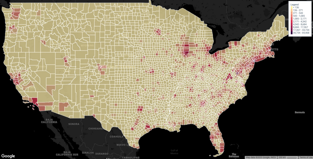
A territory map, also called choropleth map or fillled map, is a type of map in which areas (countries, states / provinces, counties, cities, districts, zip codes) are shaded or patterned in proportion to a measurement that represents an aggregate summary of a geographical characteristic with each area, such as population density, or per-capita income.
Territory maps provide an easy way to visualize how a measurement varies across a geographic area or show the level of variability within a region.
A heat map is similar, but does not use a prioti geographic area.
US population density by county (population per square mile of land area)
How to create a territory map?
Maply supports users to create territory maps in two ways:
- Create a territory heat map using location data from an existing location layer on the same map – Use this option when you want to see your location data in a territory map visualization.
- Create a territory map by uploading data using a template – Use this option when you want to have more control on which territories / areas to display and what colors they should be filled with.
Create a territory map using location data from a location layer on the same map
Follow simple steps below to create a territory map from an existing location layer
- Go to the map which your existing location layer is or simply create a new map.
- Add a new territory map layer.
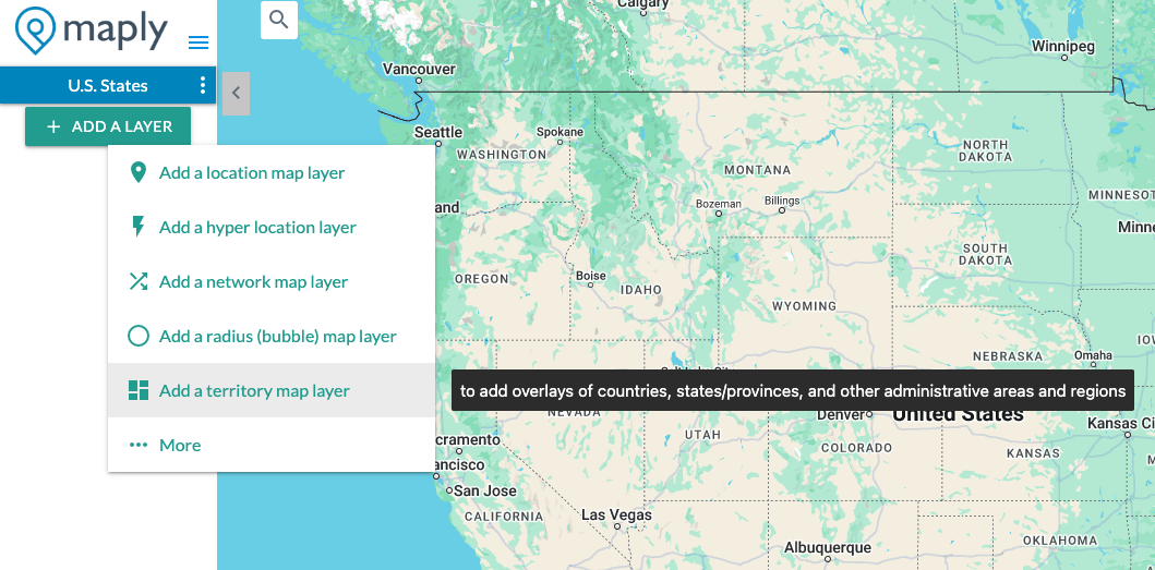
- A new window pops up.
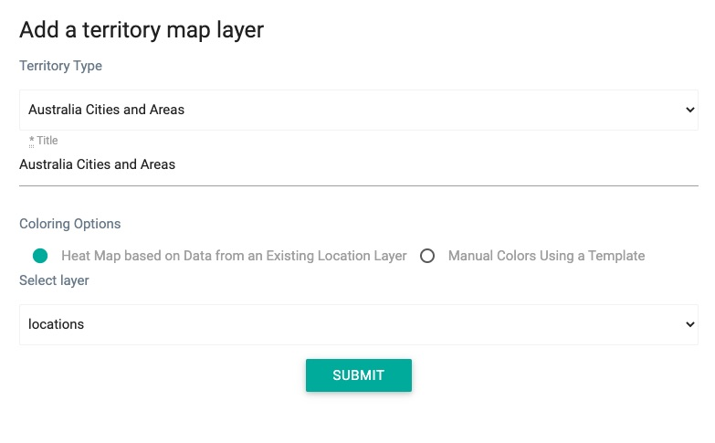
- Select a territory type.
- Select the existing location layer as the data source layer.
- Click SUBMIT button. — A newly created territory map layer will be added to the map.
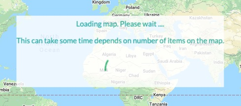
Important Note
Loading territory map layers that rely on location data from another layer may require several minutes or more. While it might seem like an extended wait, rest assured that the layer will eventually load. Your patience will pay off here.
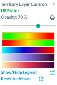
Territory Map Control Panel
Once the map is loaded, you can open the control panel from layer settings menu to adjust the opacity, as well as the heat map color options.
Adjustments will be reflected instantly (or with slight delay if too many territories) on the map so you can see their effect on the visualisation.
Here is a video tutorial on this:
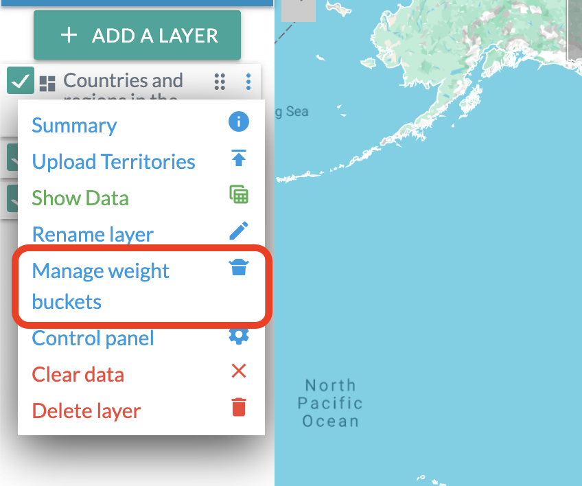
Weight buckets
After creating a territory map, you can customize how values are grouped and colored by editing the weight buckets.
Open the layer settings menu (the three dots on your territory map layer) and enter your preferred breakpoints.
Weight buckets let you manually control how Maply assigns colors to value ranges. Simply enter up to nine breakpoints between your minimum and maximum values, separated by commas—for example: 5, 10, 20. These breakpoints define the boundaries of each color bucket.
This gives you full flexibility: you can make the color scale linear, exponential, or tailored to any pattern that fits your data.
Create a territory map by uploading territories with manual colors and weights
Follow simple steps below to create a territory map by uploading territories using a template
- Go to the map in which you want to create the territory map or simply create a new map.
- Add a new territory map layer.
- A new window pops up.
- Select a territory type from the dropdown list. You can also search within the dropdown. Be sure to choose the second option Manual Color Using a Template.
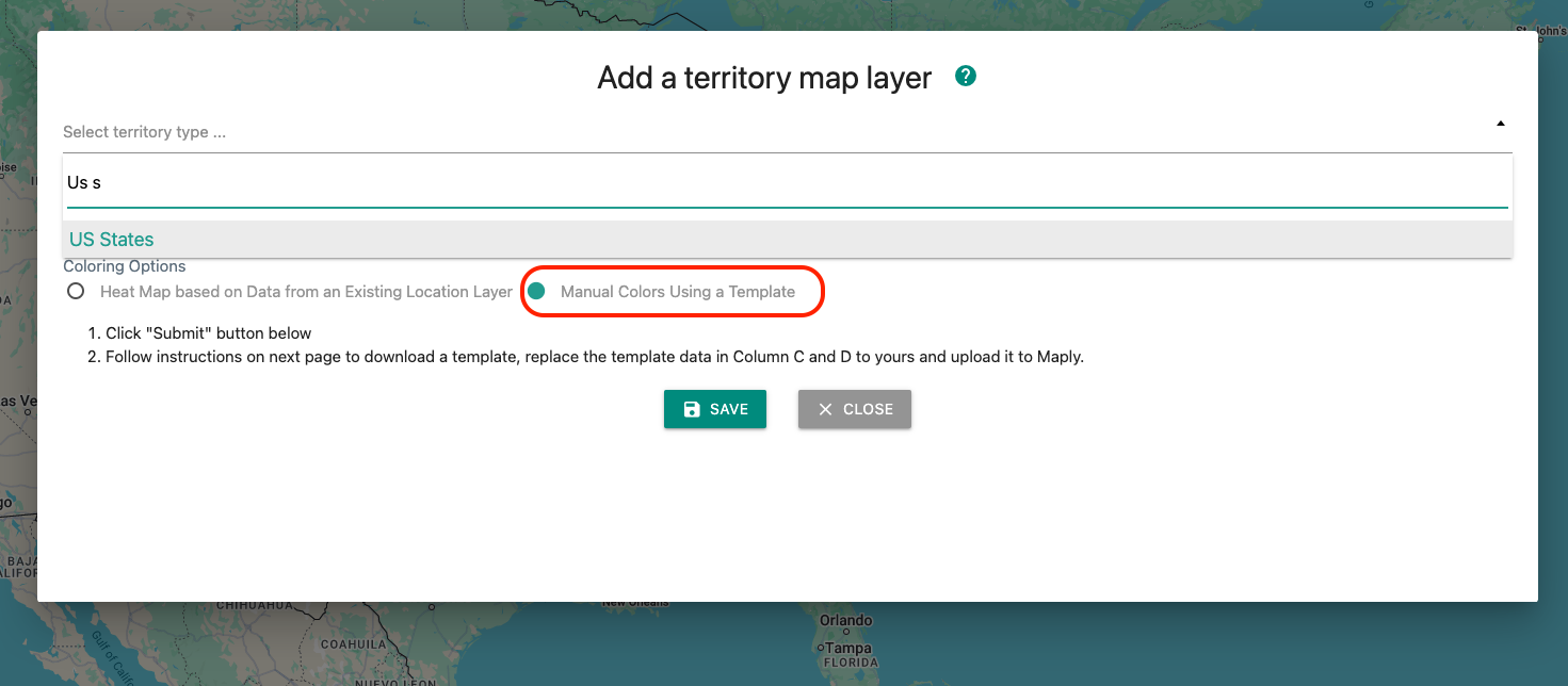
- Click Submit button. You will see a success message.
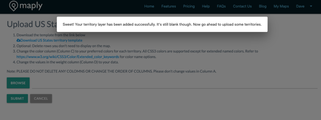
- Download the Excel template from the link provided.
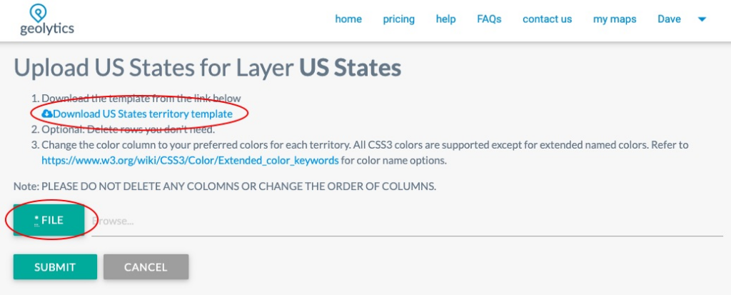
- Open the Excel template (and optionally remove those territories you don’t want to display), change the color column to your desired colors if needed. The weight column is optional. If you have any data against each territory/area, this is where the data should go.
- Once finished changing the template, go back to the upload page and select the template and click SUBMIT.
- After some processing, your newly created territory map layer is added to your map.
Here is a video tutorial on this:
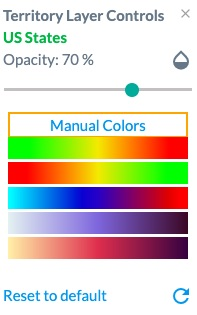
Territory Map Control Panel (Manual colors)
Once the map is loaded, you can open the control panel from layer settings menu to adjust the opacity, as well as the heat map color options.
The Heat map colors will be based on weights provided for the areas during the upload.
Adjustments will be reflected instantly (or with slight delay if too many territories) on the map so you can see their effect on the visualisation.
Note that if coloring option is manual, there is an additional option to revert to the manual colors specified during upload.
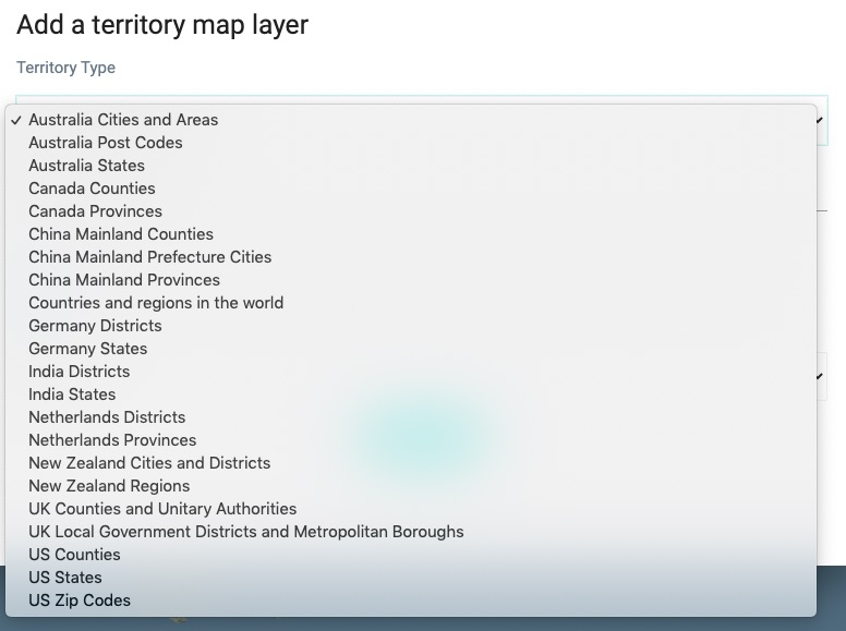
Territory types available on Maply
As of now, following 163 territory types are available on Maply:
- AR Argentina Departamento (Department)
- AR Argentina Provincia (Province)
- AT Austria Berzirk / Statutarstadt (District / Statutory City)
- AT Austria Bundesländ (State)
- AT Austria Gemeinde (Municipality)
- AU Australia SA2
- AU Australia SA3
- AU Australia SA4
- Australia Cities and Areas
- Australia Post Codes
- Australia States
- BR Brazil Estado (State)
- BR Brazil Município (Municipality)
- CA Canada Forward Sorting Areas (FSA)
- CH Switzerland Cantons
- CH Switzerland Districts
- CL Chile Comuna (Municipality)
- CL Chile Provincia (Province)
- CL Chile Región
- Canada Cities/Towns/Villages/Minicipal Districts
- Canada Counties
- Canada Provinces
- China Mainland Counties
- China Mainland Prefecture Cities
- China Mainland Provinces
- Countries and regions in the world
- Countries and regions in the world (Lite)
- DE Germany Districts
- DE Germany Postal Codes
- DE Germany Postal Codes (1-Digit)
- DE Germany Postal Codes (2-Digit)
- DE Germany Postal Codes (3-Digit)
- DE Germany States
- DK Denmark Kommuner
- DK Denmark Regioner
- ES Spain Comunidades Autónomas
- ES Spain Municipalities
- ES Spain Provincias
- Europe NUTS Level 0 – national boundaries (2024)
- Europe NUTS Level 1 – major socio-economic regions (2024)
- Europe NUTS Level 2 – basic regions for the application of regional policies (2024)
- Europe NUTS Level 3 – small regions for specific diagnoses (2024)
- Europe countries
- FI Finland Kunta|Kommun (Municipality)
- FI Finland Lääni (Province)
- FI Finland Maakunta|landskap (Region)
- FI Finland Seutukunta|Ekonomisk region (Sub Region)
- FR France Départements
- FR France Régions
- ID Indonesia Kabupaten (Regency)
- ID Indonesia Propinisi (Province)
- IE Ireland County
- IE Ireland Municipal District
- IT Italy Districts
- IT Italy Regiones
- India Districts
- India States
- JP Japan Ken (Prefecture)
- JP Japan Shi / Machi (City / Town)
- Malaysia Districts
- Malaysia States
- NO Norway Fylke (County)
- NO Norway Kommuner (Municipality)
- NZ New Zealand Cities and Districts
- NZ New Zealand Postal Codes
- NZ New Zealand Regions
- NZ New Zealand Statistical Areas 2 (SA2) 2023
- NZ New Zealand Statistical Areas 3 (SA3) 2023
- Netherlands Districts
- Netherlands Provinces
- PE Peru Districts
- PE Peru Provinces
- PL Poland Gmina (Municipality)
- PL Poland Powiat (County)
- PL Poland Województwo (Voivodeship)
- PT Portugal Concelho (Municipality)
- PT Portugal Distrito (District)
- RU Russia Oblast/Respublika (Region/Republic)
- RU Russia Raion/Gorod (District/City)
- SE Sweden Kummun (Municipality)
- SE Sweden LA Omraden (Region)
- SE Sweden Lan (County)
- SG Singapore URA Planning Areas
- SG Singapore URA Region
- SG Singapore URA Subzones
- UA Ukraine Oblasts
- UK Counties and Unitary Authorities
- UK Local Government Districts and Metropolitan Boroughs
- UK Parliamentary Constituencies (Dec 2020)
- UK Postal Areas (AB L A ..)
- UK Postal Districts (AB10 B11 1 10 ..)
- UK Postal Sectors (AB101 B106 11 12 ..)
- UK Wards (May 2021)
- US 119th Congressional Districts for Illinois (2024)
- US 119th Congressional Districts for South Caroline (2024)
- US Chicago Wards (2023)
- US Counties
- US School District (Elementary + Unified) for Illinois (2024)
- US State Legislative District (SLD) Lower Chamber for Illinois (2024)
- US State Legislative District (SLD) Lower Chamber for South Caroline (2024)
- US State Legislative District (SLD) Upper Chamber for Illinois (2024)
- US State Legislative District (SLD) Upper Chamber for South Caroline (2024)
- US States
- US Unified School District for Illinois
- US Unified School District for Kansas (2025)
- US United States Zip Codes Alabama (AL)
- US United States Zip Codes Alaska (AK)
- US United States Zip Codes Arizona (AZ)
- US United States Zip Codes Arkansas (AR)
- US United States Zip Codes California (CA)
- US United States Zip Codes Colorado (CO)
- US United States Zip Codes Connecticut (CT)
- US United States Zip Codes Delaware (DE)
- US United States Zip Codes District of Columbia (DC)
- US United States Zip Codes Florida (FL)
- US United States Zip Codes Georgia (GA)
- US United States Zip Codes Hawaii (HI)
- US United States Zip Codes Idaho (ID)
- US United States Zip Codes Illinois (IL)
- US United States Zip Codes Indiana (IN)
- US United States Zip Codes Iowa (IA)
- US United States Zip Codes Kansas (KS)
- US United States Zip Codes Kentucky (KY)
- US United States Zip Codes Louisiana (LA)
- US United States Zip Codes Maine (ME)
- US United States Zip Codes Maryland (MD)
- US United States Zip Codes Massachusetts (MA)
- US United States Zip Codes Michigan (MI)
- US United States Zip Codes Minnesota (MN)
- US United States Zip Codes Mississippi (MS)
- US United States Zip Codes Missouri (MO)
- US United States Zip Codes Montana (MT)
- US United States Zip Codes Nebraska (NE)
- US United States Zip Codes Nevada (NV)
- US United States Zip Codes New Hampshire (NH)
- US United States Zip Codes New Jersey (NJ)
- US United States Zip Codes New Mexico (NM)
- US United States Zip Codes New York (NY)
- US United States Zip Codes North Carolina (NC)
- US United States Zip Codes North Dakota (ND)
- US United States Zip Codes Ohio (OH)
- US United States Zip Codes Oklahoma (OK)
- US United States Zip Codes Oregon (OR)
- US United States Zip Codes Pennsylvania (PA)
- US United States Zip Codes Rhode Island (RI)
- US United States Zip Codes South Carolina (SC)
- US United States Zip Codes South Dakota (SD)
- US United States Zip Codes Tennessee (TN)
- US United States Zip Codes Texas (TX)
- US United States Zip Codes Utah (UT)
- US United States Zip Codes Vermont (VT)
- US United States Zip Codes Virginia (VA)
- US United States Zip Codes Washington (WA)
- US United States Zip Codes West Virginia (WV)
- US United States Zip Codes Wisconsin (WI)
- US United States Zip Codes Wyoming (WY)
- US Zip Codes
- ZA South Africa District Municipality
- ZA South Africa Local Municipality
- ZA South Africa Province
- ZA South Africa Ward
Let us know if the territory type you are looking for is not included above.