What is the Center of Gravity (CoG) of geographical locations?
The Center of Gravity (CoG) of geographical locations is the optimal point where the weighted average distance to each specified location is minimized. This concept is essential for efficient planning and logistics.
When planning a new facility—whether it’s a warehouse, distribution center, sales office, factory, restaurant, school, or shopping mall—determining the best location is critical. Properly locating a facility can save substantial setup and operational costs, reduce travel time, and lower transportation expenses. Additionally, it benefits the environment by reducing carbon emissions.
How to find the Center of Gravity?
Step 1: Create a map and add a location layer.
Here is a video guide on how to do that. It’s important to provide a weight to each location. This weight can be monthly shipments, number of visits, or number of orders, any number that represents the demand of that location.
Step 2: Select the “Center of Gravity” option from the layer menu

In the pop-up window, choose the number of COGs to be calculated (up to 50).

Confirm to start the search. It usually takes just a few seconds to come back with a result for less than a few thousand locations. For larger datasets, this could take longer.
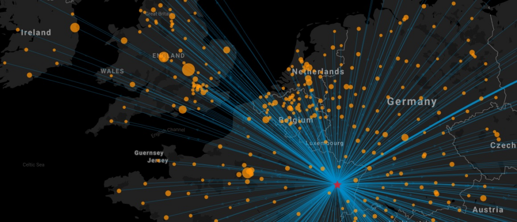
Identified CoG will be shown in a new location layer. A new network map layer will also be added to connect the CoG location to each destination.

Benefits of finding the CoG with Maply
- Ease of Use: Quick and straightforward process.
- Preliminary Insights: Provides initial guidance on potential locations.
- Data Validation: Map Visualisation can be used to validate shipments or sales data
- Communication tool: Center of gravity maps can be used to communicate complex concepts in an easy-to-understand format. This makes CoG map an excellent tool for building consensus among diverse groups.
- Data Export: Calculation results, including CoG information and allocation assignments can be exported to CSV for further analysis and reporting
Things to take note:
- Distance Measurement: Calculations use straight-line (as-the-crow-flies) distance, not actual road distance.
- Initial Step: Identifying the CoG is the first step in site selection. Comprehensive evaluation should include factors like actual transport costs, facility operating costs, manpower availability, infrastructure, taxes, government incentives, and future trends.
- Cost Optimization: The ultimate goal is to minimize total logistics costs, with transport costs being only one part of the overall equation.
By understanding and leveraging the Center of Gravity for your geographical locations, you can optimize facility placement, reduce costs, and enhance operational efficiency. Start using Maply today to find your optimal site location.